
Contents
Catherine Kearns opens her study of Iron Age environments with Kitchener's verdict of 1879: "Cyprus is an island of sudden changes. Both climate and landscape are subject to rapid variations" [1, p. 266]. The ancient climate of the island is much harder to pin down than that remark suggests. There are few long records from Cyprus itself, most of them from one lagoon near Larnaca, and the best-known of them has become the centre of an argument about the end of the Late Bronze Age. This entry sets out what the island's own evidence shows about sea level, coasts, rainfall and forests from the first farmers to the Hellenistic kings, which records it comes from, how firmly each is dated, and where specialists disagree. It sits beside the entries on population and demography and food and diet, which deal with how people lived within these limits; the island before people is covered under Cyprus before humans.
A dry island with a thin record
The modern baseline is semi-arid. The area around the Larnaca Salt Lake, the source of the most-cited ancient record, is "one of the driest parts of the island", with 351.5 mm of rain a year and a mean annual temperature of 19.6°C [2, p. 3]. In a climate like this, runs of dry years matter more than averages. Meyer and Bernard Knapp note that historically documented multi-year droughts in Cyprus's "semi-arid environment" had "devastating impacts on agriculture, including famine conditions" [3, p. 448]. Recent work, Kearns writes, "has rightly challenged the island's historical epithet makarios, meaning 'blessed'", by stressing "the shifty marginality and erratic nature of Cypriot environments" [1, p. 266].
The difficulty is that the island's past environments have been studied far less than its tombs and temples. Kearns observes that there is little information "on abrupt or 'sudden' changes in past landscape and climates on Cyprus", in contrast to Anatolia, which has better records [1, p. 266]. "Archaeobotanical investigations are still not widely implemented on the island", even though du Plat Taylor and Stewart collected seeds and charcoal early on, and so "we know little about past vegetation cover, the composition of forests that may have extended further into the lowlands, or paleosols" [1, p. 268]. Archaeologists have leaned on archives from elsewhere in the Mediterranean to fill the gap.
Kearns also points to an assumption that has held research back: "an apparent presumption that the environments of Cyprus have remained relatively the same", with "hot dry summers and cold wet winters, with some significant coastline change" [1, p. 268]. That picture is now being tested, by the Salt Lake pollen work of Kaniewski's team in 2013, by a tree-ring reconstruction of rainfall published by Griggs and colleagues in 2014, and by the synthesis of Knapp and Sturt Manning in 2016 [1, p. 268]. Dating is uneven across the periods. Radiocarbon work on prehistory is advancing, while for the Iron Age Kearns notes a "general absence of absolutely dated remains" [1, p. 269].
The records: what exists and how it is dated
The core that carries most of the argument is B22, drilled by Kaniewski and colleagues in the Larnaca Salt Lake Complex beside the Late Bronze Age town of Hala Sultan Tekke. The complex today consists of four main lakes and a coastal lagoon system resembling "semi-arid temporary salt lakes" [2, p. 3]. The team analysed 84 pollen samples, together with dinoflagellate cysts (the resting cells of marine plankton, which show whether the water was sea or lagoon) and the charcoal particles on the pollen slides, which record fire [2, p. 3]. The top 250 cm of the core is "sterile in bioindicators (salty deposits)", and terrestrial plant remains are "scarce", which limits how far the record reaches [2, p. 3].
The chronology rests on three AMS radiocarbon dates. The base of the core gave 3290±30 BP (3580 to 3450 cal BP at two sigma, roughly 1630 to 1500 BC); a sample in the middle gave 3140±30 BP (roughly 1450 to 1380 BC); and the uppermost dated sample gave 820±30 BP, which falls in AD 1160 to 1270 [2, p. 3]. Everything between those points is interpolated. The authors then correlated the Cypriot curve statistically with their own record from Gibala-Tell Tweini on the Syrian coast, obtaining a coefficient of +0.626 at zero lag [2, p. 6]; the Syrian site is discussed under Ugarit and the Levant.
A second generation of cores is on its way. Fischer and Bürge, who excavate at Hala Sultan Tekke, report that new cores were drilled in the dry lake bed in 2016 [6]. For the Iron Age, Kearns uses the carbon-isotope ratios of charcoal from excavated sites to track rainfall [1, p. 267], and for the coasts the main archive is a survey of raised and drowned beach deposits, beachrock and archaeological installations around the island by Ehud Galili and colleagues [4]. Long records from cave deposits and inland marshes elsewhere in the eastern Mediterranean are cited in these studies as regional comparisons; none of the sources used here reports such a record from Cyprus itself.
The signals that the island's own evidence supports, and the sources for each, are these:
| Period | Signal | Proxy or site | Source |
|---|---|---|---|
| Early Holocene (first Neolithic settlers) | Sea level 40 to 50 m below today, rising about 13 mm a year | Beach deposits and beachrock around Cyprus | Galili et al. 2015 [4] |
| About 7,000 years ago | Sea level about 9 m below today | Coast near Troulli | Galili et al. 2015 [4] |
| c.1600 to 1350 BC | Salt Lake an open, sheltered marine embayment | Core B22: seagrass fibres, dinoflagellate cysts | Kaniewski et al. 2013 [2] |
| c.1450 to 1350 BC | Embayment turns into a lagoon | Core B22 | Kaniewski et al. 2013 [2] |
| c.1200 to 850 BC | Drier; rain and groundwater probably insufficient for farming (dating disputed) | Core B22 pollen | Kaniewski et al. 2013 [2]; critique in Meyer & Knapp 2021 [3] |
| 3250 to 2850 cal BP | Farming output declining, lowest 3150 to 2850 cal BP | Radiocarbon-dated seeds and olive stones, Cyprus and Syria | Kaniewski et al. 2019, via Meyer & Knapp 2021 [3] |
| c.1000 BC ± 300 years | Driest Bronze Age interval in the eastern Mediterranean | Regional synthesis of proxies | Finné et al. 2019, via Meyer & Knapp 2021 [3] |
| After the Late Bronze Age | Wetter; cultivation and tree crops resume (poor resolution) | Core B22 pollen | Kearns 2022 [7] |
| c.150 BC and c.AD 350 | Kition harbour becomes a leaky lagoon, then a salt lake | Harbour cores at Kition-Bamboula | Morhange et al., via Kaniewski et al. 2013 [2] |
| Last 2,000 years | Coast vertically stable within ±0.3 m | Ancient fish tanks and quarries | Galili et al. 2015 [4] |
Neolithic coasts: lower seas and coastal springs
When the first farming communities of the Neolithic settled Cyprus, the sea stood much lower than it does now. Galili and colleagues put early Holocene sea level "about 40–50 m below" the present, and find that tectonic uplift of the coast since then "did not exceed 1.2–1.5 m" [4, pp. 179, 212]. The rise was fast by geological standards, up to about 13 mm a year, but that amounts to "around 32 cm per life span", a change that "could hardly have been detected by the Neolithic people" [4, p. 212]. Land that was dry coast then is now under water.
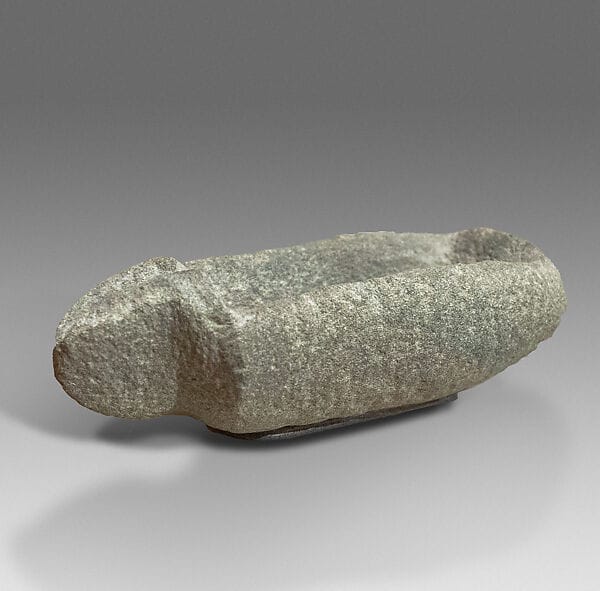
By about 7,000 years ago the sea was still "about 9 m lower" than today. On that basis Galili's team judges it "most unlikely" that a structure at Troulli, published by Dreghorn as a Neolithic jetty, was one [4, p. 212]. The same study draws attention to water. Along parts of the coast, springs emerge where impermeable Pliocene marls meet porous Pleistocene deposits. The Early Neolithic settlements of Mylouthkia and Akanthou lie next to visible springs, which the authors say "may not be incidental", and the wells found there are "the earliest wells known so far" [4, pp. 179, 212]. The stone vessels of the Neolithic village of Khirokitia, such as a spouted diabase bowl excavated there in 1934 and now on loan from the Cyprus Museum to the Metropolitan Museum, were made from local stone. The Early Holocene fauna and the arrival of people are treated in Cyprus before humans.
As far as we know, no Cypriot record yet dates the climatic events that archaeologists often invoke for the later prehistoric Near East, including the dry episode around 2200 BC, so this entry does not assign any change in the Early Bronze Age to climate.
The Late Bronze Age: Hala Sultan Tekke and the Salt Lake core
The B22 core tells a story in three steps. From about 1600 to 1350 cal BC the lake complex "remained constantly connected to the sea". Fibres of the seagrass Posidonia oceanica and marine dinoflagellate cysts point to a "sheltered marine embayment", a natural harbour beside the town [2, p. 3]. Between about 1450 and 1350 cal BC the embayment changed to a lagoon, a shift the authors describe as "concomitant with the decreasing prosperity of the Hala Sultan Tekke harbour" [2, p. 3].
The third step is the one that made the paper well known. Between about 1200 and 850 cal BC, Kaniewski and colleagues write, the area "turned into a drier landscape, the precipitation and groundwater probably became insufficient to maintain sustainable agriculture in this place" [2, p. 6]. They support this with regional records: oxygen isotopes from Soreq Cave and Ashdod, the Dead Sea, reduced Nile floods and low discharge from the Tigris and Euphrates [2, p. 6]. The core is "consistent with a termination of the drought event during the 9th century BC", and the authors note that state-level polities reappear on the island in the 8th century [2, p. 6], the period described under Cypro-Geometric and Cypro-Archaic.
The authors link the onset of the drought to the crisis at the end of the Late Bronze Age and to the "Sea People event", which they place at the Late Cypriot IIC to IIIA transition, 1220 to 1190 cal BC [2, p. 6]. Cline, in 1177 B.C., quotes their conclusion that "the LBA crisis coincided with the onset of a ca. 300-year drought event 3200 years ago", which they say caused "crop failures, dearth and famine". He is careful about it: "If Kaniewski and his colleagues are correct, they have retrieved the direct scientific evidence that scholars have been seeking for a drought that may have contributed to the end of the Late Bronze Age" [5, p. 146].
After the dry phase, the pollen shows more cultivated plants. Kearns reads it this way: "while the chronological resolution is poor, it suggests a post-Bronze Age re-initiation of agriculture and arboriculture that took advantage of wetter conditions" [7, p. 128]. The open-access paper is available from PLoS ONE, and the history of excavation at the site is told in the article on Paul Åström.
Why drought is not the whole story of 1200 BC
The drought hypothesis has drawn four kinds of criticism, and together they are the reason this entry treats it as one pressure among several.
The first is dating. Knapp and Manning showed in 2016 that "the dates offered are sparse and lack adequate chronological resolution" [3, p. 447]. The three AMS dates in B22 cluster around 1590 BC, 1420 BC and AD 1220 [2, p. 3], so none falls inside the 1200 to 850 BC window where the drought is placed; its timing depends on interpolation and on the correlation with Syria. In 2019 the Kaniewski team added ten radiocarbon dates from Cyprus and nineteen from Syria, on seeds and olive stones, spanning about 1320 to 1025 BC. Meyer and Knapp call this "a step in the right direction" [3, p. 447]. The new series shows agricultural production declining from 3250 cal BP and reaching its lowest point between 3150 and 2850 cal BP [3, p. 448]. Regional syntheses have the same limit. Finné and colleagues reviewed eighteen proxy records in 2011 and found that their date ranges "can rarely be resolved to the point that they can be related to specific events"; a later study by Finné and colleagues in 2019 identifies about 1000 BC, plus or minus 300 years, as the driest Bronze Age interval in the eastern Mediterranean [3, p. 448].
The second is the neighbouring town. Fischer and Bürge, who excavate Hala Sultan Tekke, argue that climate models "are of quite limited relevance to the discussion why Hala Sultan Tekke was abandoned, while at the same time and under the same climatological conditions, the nearby major site of Kition survived" [6]. Kition lies about 6 km away [6]. They also note "the problems with precise radiocarbon dates", find "no undisputable proof" that the harbour silted up in Late Cypriot IIIA, and describe a destruction of Hala Sultan Tekke "roughly in mid-12th century BCE" followed by rebuilding with no gap between Strata 2 and 1 [6]. Their point about silting concerns a later phase than the lagoon shift of c.1450 to 1350 BC seen in the core, so the two findings do not strictly contradict each other.
The third is the pattern of survival. Meyer and Knapp list Enkomi, Kition and Palaepaphos as the only towns that survived the destructions and abandonments at the end of the period [3, p. 448]. A climate shift acting on the whole south-east coast does not by itself explain why some centres continued and others did not. Meyer and Knapp frame the mechanism conditionally: if the drought occurred, it would have put selective pressure on regional centres that depended on farming [3, p. 448].
The fourth is method. Meyer and Knapp accept drought as a possible "stressor" but call the case "still provisional", and warn against treating social change as "a black box: climates got drier and society collapsed, but the actual mechanisms of change remain vague" [3, p. 447]. Their paper is open access. The line this entry takes follows them: drought is one stressor that may have weighed on Cypriot farming around 1200 BC, alongside the destructions, abandonments and movements of people described under the Late Bronze Age, the Mycenaeans and the Philistines, and it is not a single cause of the changes. Village life in the period is described in Late Bronze Age village life.
Forests, copper fuel and the "sixteen deforestations"
Copper smelting burns charcoal, and that link produced one of the most quoted numbers in Cypriot environmental history. Constantinou, in work of 1982 and 1992, estimated that Cyprus "must have been deforested up to sixteen times in a 3,500 year period" to make the charcoal behind about four million tons of ancient slag, the waste from about 200,000 tons of copper [8, p. 128]. He described the island's development as "a sustained and reckless attack by man on the forests" [8, p. 128]. The figure is reported here as Constantinou's estimate, known through Michael Jones's 2007 review.
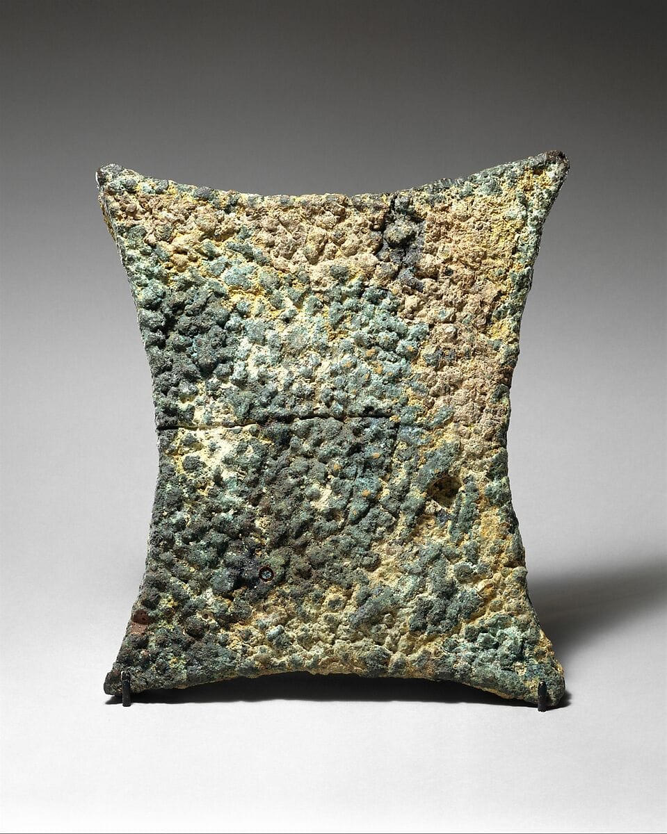
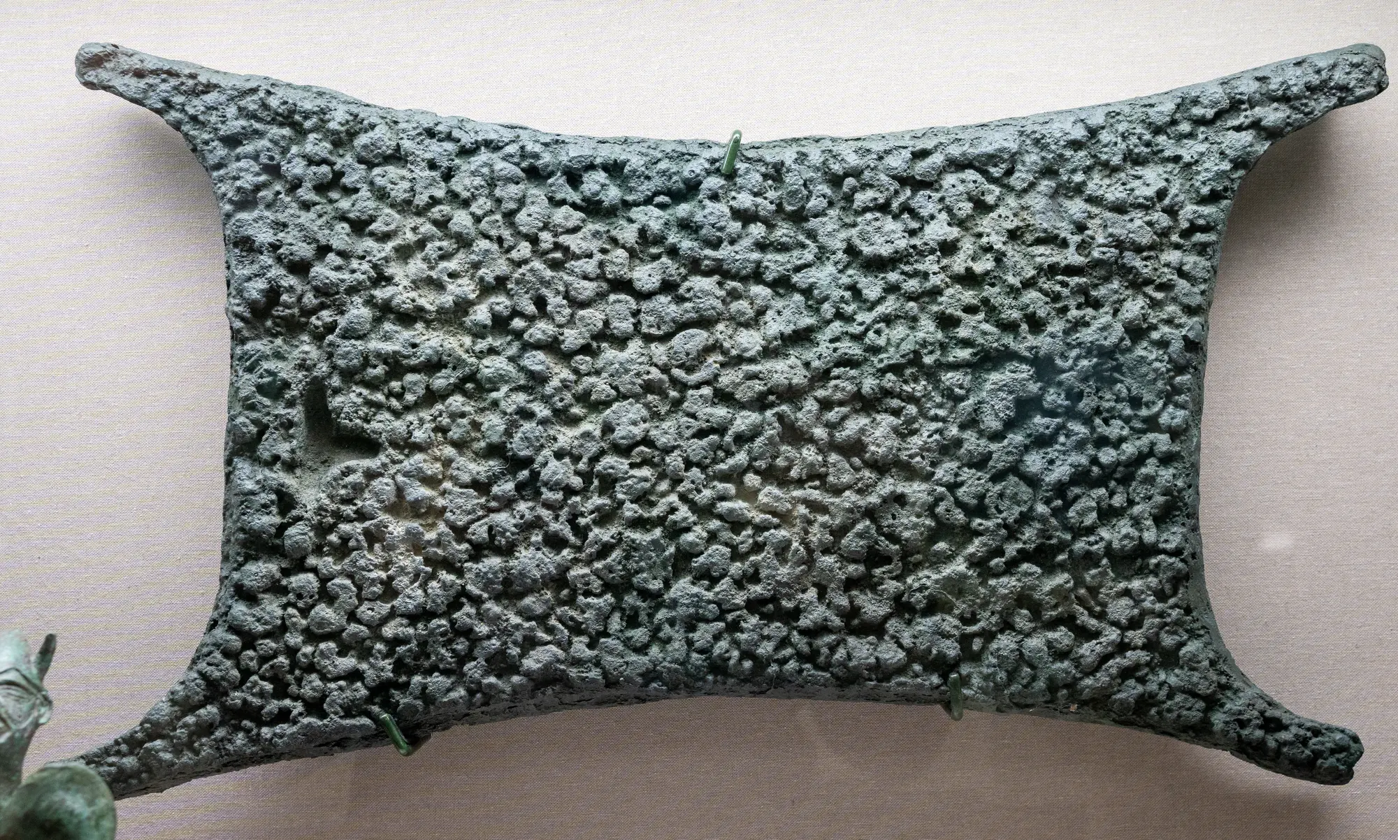
The same estimate contains its own qualification. Constantinou also reckoned that the Troodos forests could regenerate "within 80-100 years" [8, p. 128], so repeated clearance over three and a half millennia does not imply a permanently bare island. Meiggs thought the impact of mining on the forests "may be exaggerated", and Wertime suggested in 1982 that coppiced golden oak was grown for fuel; Pliny and Theophrastus both say young trees make better charcoal [8, p. 128]. A Late Bronze Age oxhide ingot in the Metropolitan Museum, weighing 28.6 kg, and a copper ingot of the twelfth century BC in the Cyprus Museum show the scale of the product. Smelting technology and fuel are covered in the copper metallurgy entry and in the article Copper kingdoms of ancient Cyprus.
The ancient writers did not blame copper alone. Strabo, quoting Eratosthenes (Geography 14.6.5), places most of the blame for the loss of Cypriot forest on "extensive clearing for arable farming" [9, p. 330]. Theophrastus mentions decrees of the Cypriot kings protecting trees and preventing their cutting, which Gregory Votruba calls "the earliest record of forest management" [9, p. 330]; the two modern sources that cite the passage give different book references, so none is given here. Votruba, drawing on Meiggs, notes that the forests of Cyprus and Lebanon saw "extensive felling during the Hellenistic period, not least for the construction of the Syrian and Egyptian fleets", and that a passage of Ammianus Marcellinus implies they had recovered by the fourth century AD [9, p. 330]. The Hellenistic context is set out under Hellenistic Cyprus, and shipbuilding under seafaring and ships.
Direct evidence from Cyprus is still missing. Kearns writes that the data are "not available yet" to show on the island the kind of tree-cutting and erosion by grazing documented at Gordion in Anatolia [7, p. 128]. What the settlement record does show, in her reading, is oscillation that suggests "sensitive interactions between intensive agriculture and pastoralism along river valleys and into more marginal hillslopes" [7, p. 128]. Across Anatolia, the Levant and the Aegean, the pollen phase of cleared farmland known as the Beyşehir Occupation Phase began at different times in different places, in the Late Bronze Age, around the eighth century BC or as late as the Hellenistic period, and pine and oak return around the seventh century AD [7, p. 128]. For Cyprus, the older picture of an island stripped by smelters rests on a single estimate; the verified evidence points to clearance for fields, smelting and ship timber, working at different rates in different periods, with regrowth between.
Harbours, lagoons and a stable coastline
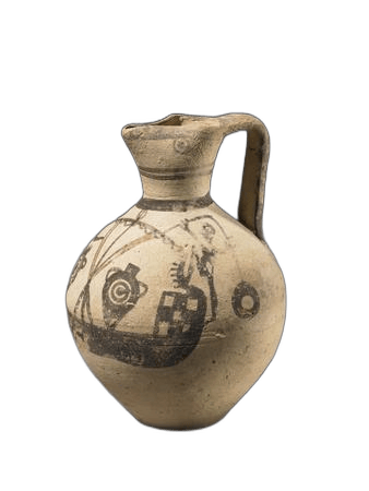
The coasts of Cyprus changed shape in antiquity, mostly through sediment rather than movement of the land. At Hala Sultan Tekke the marine embayment became a lagoon around 1450 to 1350 BC [2, p. 3]. At Kition-Bamboula, cores studied by Morhange and colleagues show that the sheltered marine harbour "turned to a leaky lagoon at ca. 150 cal yr BC, and to a salt lake at ca. 350 cal yr AD" [2, p. 3]. Both of the ancient harbours of the Larnaca bay thus ended as the salt lakes seen today. Seafaring from these harbours is illustrated by a Cypro-Archaic Bichrome jug painted with a merchant ship in the British Museum; the Iron Age town is discussed in the entry on the Phoenicians.
Specialists have disagreed about whether the land itself rose or fell. Morhange and colleagues proposed uplift at Kition in 2000; Gifford, in 1980 and 1985, proposed the opposite, subsidence; and Yon reported uplift at Cape Kiti in 1994 [4, p. 212]. Galili's team, working from ancient fish tanks, quarries and beach deposits around the whole island, concludes that there has been "no significant vertical land changes or relative sea-level change (less than ±0.3 m) of the Cyprus coasts in the last 2 ka" [4, p. 212]. Once sea level stabilised after the mid-Holocene, they argue, "marine erosion, sedimentation and surface runoff" became the main forces on the coast, and earthquakes were "of secondary effect only" [4, p. 212]. The Roman and Byzantine fishponds at Lambousa worked with the sea about 1 m higher than today, yet Galili argues they could function now if they were maintained [4, p. 212]. The study is at the Geological Society's Special Publications.
On land, people adjusted their fields. At Politiko-Troullia, between the second and first millennia BC, farmers changed how they built and maintained terrace walls, which Fall and colleagues relate to possible changes in rainfall and erosion [1, p. 269]. Kearns's own survey of the Archaic countryside, in her 2019 chapter and her 2022 book, reads shifts in settlement against these environmental records [1, p. 269; 7, p. 128].
What can and cannot be said
The island's own records support a short list of statements. Sea level was far lower when the first farmers arrived and rose too slowly for any one generation to notice. The early wells at Mylouthkia and Akanthou sit beside coastal springs. The Larnaca bay held an open harbour at Hala Sultan Tekke until the fifteenth or fourteenth century BC, and Kition's harbour silted to a lagoon in the Hellenistic period and to a salt lake by the fourth century AD. The coastline has not moved vertically by more than about 30 cm in two thousand years. A drier phase around the end of the Late Bronze Age is recorded in the Salt Lake pollen and supported by regional records, but its start and length depend on few dates, and towns a few kilometres apart fared differently under it. For the forests, the claim of sixteen deforestations is one scholar's calculation, qualified by his own regeneration figure and by the ancient writers' emphasis on farmland.
Much remains open. There is as yet no dated Cypriot sequence for the climate of the Neolithic or Early Bronze Age, the Iron Age charcoal isotope results are not reviewed here, and the cores drilled in the Salt Lake in 2016 are not yet part of the published argument summarised above. The entries on the chronology of each period give the archaeological context into which any new record will have to fit.
Objects on this page
References
- 1.Kearns, C. (2019). Discerning “favorable” environments: Science, survey archaeology, and the Cypriot Iron Age. In C. Kearns & S. W. Manning (Eds.), New directions in Cypriot archaeology. Cornell University Press. https://doi.org/10.7591/9781501732706-012
- 2.Kaniewski, D., et al. (2013). Environmental roots of the Late Bronze Age crisis. PLoS ONE, 8(8), e71004. https://doi.org/10.1371/journal.pone.0071004
- 3.Meyer, N., & Knapp, A. B. (2021). Resilient social actors in the transition from the Late Bronze to the Early Iron Age on Cyprus. Journal of World Prehistory. https://doi.org/10.1007/s10963-021-09163-7 (open access)
- 4.Galili, E., Şevketoğlu, M., Salamon, A., Zviely, D., Mienis, H. K., Rosen, B., & Moshkovitz, S. (2015). Late Quaternary beach deposits and archaeological relics on the coasts of Cyprus, and the possible implications of sea-level changes and tectonics on the early populations. Geological Society, London, Special Publications, 411. https://doi.org/10.1144/SP411.10
- 5.Cline, E. H. (2014). 1177 B.C.: The year civilization collapsed. Princeton University Press.
- 6.Fischer, P. M. (2019). The occupational history of the Bronze Age harbour city of Hala Sultan Tekke, Cyprus. Ägypten und Levante / Egypt and the Levant, 29, 189–230. Austrian Academy of Sciences Press.
- 7.Kearns, C. (2022). The rural landscapes of Archaic Cyprus: An archaeology of environmental and social change. Cambridge University Press.
- 8.Jones, M. R. (2007). Oxhide ingots, copper production, and the Mediterranean trade in copper and other metals in the Bronze Age (Master's thesis). Texas A&M University.
- 9.Votruba, G. F. (2007). Imported building materials of Sebastos Harbour, Israel. International Journal of Nautical Archaeology. https://doi.org/10.1111/j.1095-9270.2007.00152.x